K2 Mountain – Complete Travel & Trekking Guide: Everything You Need to Know
Plan your ultimate adventure with our K2 Mountain guide. Learn about K2's height, location, history, weather, and how to trek to K2 Base Camp in Pakistan.
Gilgit-Baltistan ExplorersSeptember 29, 202617 min read
#K2 Mountain#K2 Pakistan#K2 mountain Pakistan#K2 location#where is K2 located#K2 height#K2 elevation#K2 facts#K2 history#K2 Base Camp#K2 Base Camp trek#K2 Base Camp trek Pakistan#K2 trek#K2 expedition#K2 climbing#K2 summit#K2 weather#best time to visit K2#K2 Base Camp itinerary#K2 Base Camp cost#K2 Base Camp difficulty#Concordia Pakistan#Baltoro Glacier#Karakoram mountains#Gilgit-Baltistan#Pakistan trekking#mountains in Pakistan
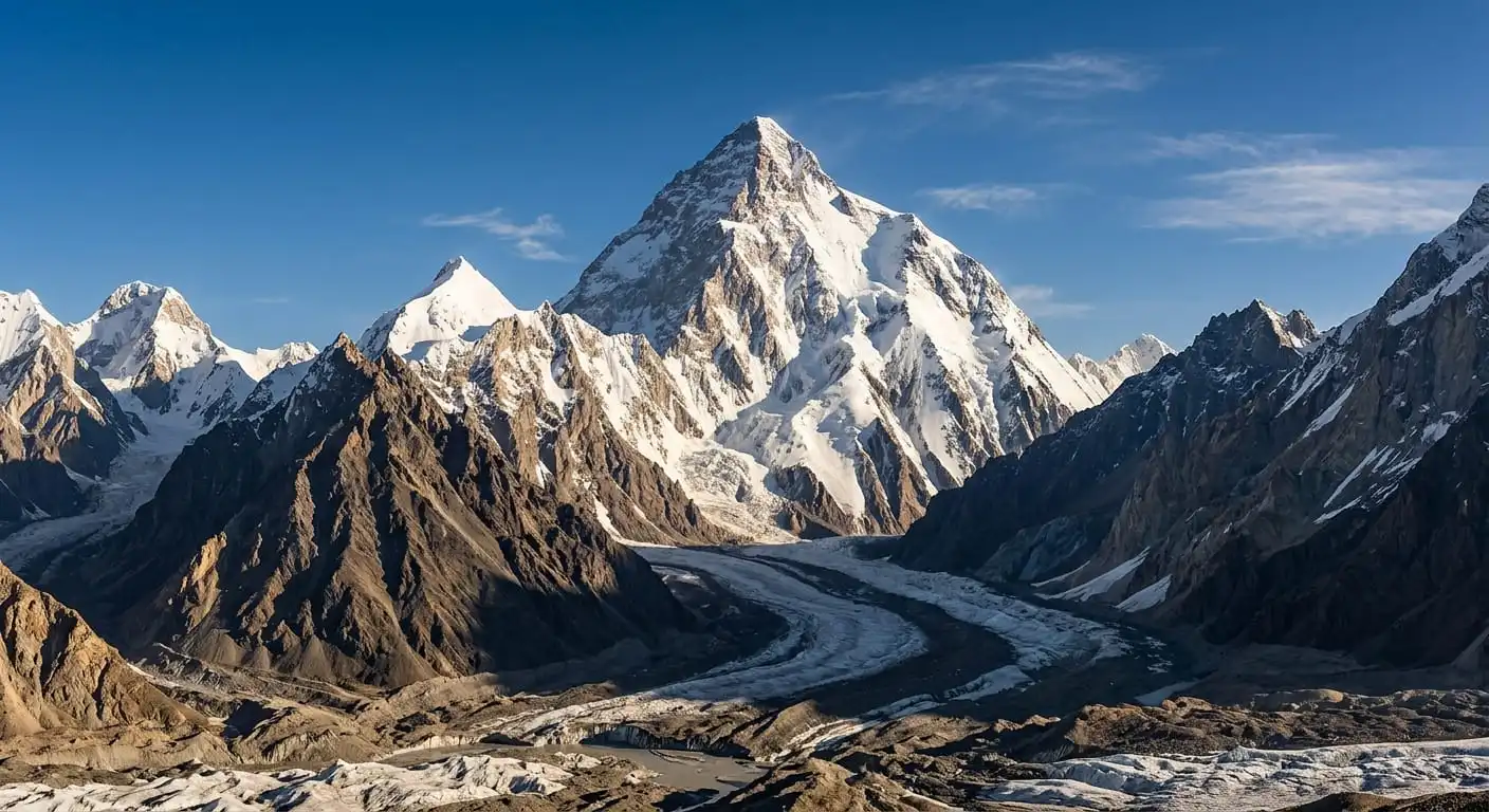
Rising dramatically into the sky like a razor-sharp pyramid of rock and ice, K2 Mountain stands as the ultimate symbol of wild mountain beauty and extreme alpine challenge. Located deep within the rugged Karakoram range of Gilgit-Baltistan, Pakistan, K2 is widely regarded as the most formidable peak on Earth. While Mount Everest holds the title for pure height, K2 commands a far greater level of reverence among mountaineers, explorers, and adventure travelers worldwide due to its sheer technical difficulty, volatile weather, and untamed surroundings.
TABLE OF CONTENTS
- Introduction
- What Is K2 Mountain?
- Where Is K2 Located?
- K2 Elevation and Height
- The Name and History of K2
- K2 Weather and Climate Conditions
- Best Time to Visit K2 and Trek to Base Camp
- The K2 Base Camp Trek: An Overview
- Detailed 14-Day K2 Base Camp Itinerary
- Cost Breakdown for K2 Base Camp Trek
- Permits, Visas, and Logistics
- Essential Packing List for Trekking to K2 Base Camp
- Safety, Health, and Altitude Sickness
- Responsible Tourism and Environmental Conservation
- Frequently Asked Questions (FAQs)
- Final Travel Checklist
- Conclusion & Call to Action
Dreaming of seeing the Savage Mountain? Explore our complete guide to K2 Mountain, covering location, history, weather, gear, and the iconic K2 Base Camp trek!
K2 Mountain – Complete Travel & Trekking Guide
Introduction
Rising dramatically into the sky like a razor-sharp pyramid of rock and ice, K2 Mountain stands as the ultimate symbol of wild mountain beauty and extreme alpine challenge. Located deep within the rugged Karakoram range of Gilgit-Baltistan, Pakistan, K2 is widely regarded as the most formidable peak on Earth. While Mount Everest holds the title for pure height, K2 commands a far greater level of reverence among mountaineers, explorers, and adventure travelers worldwide due to its sheer technical difficulty, volatile weather, and untamed surroundings.
Trekking through the Karakoram to stand in the shadow of K2 at its famous Base Camp is a life-changing journey. It takes adventurers past massive glacial rivers, through legendary amphitheaters of granite spires like Concordia, and into the heart of the world's most concentrated cluster of 8,000-meter giants. This comprehensive K2 Mountain Travel & Trekking Guide delivers essential, fact-checked insights for anyone looking to understand K2's rich history, prepare for a high-altitude expedition, or execute the iconic trek to K2 Base Camp safely and responsibly.
What Is K2 Mountain?
Featured Snippet Answer:
K2 Mountain is the second-highest peak on Earth, standing at an elevation of 8,611 meters (28,251 feet) above sea level. Located in the Karakoram range of Gilgit-Baltistan, Pakistan, K2 is renowned for its iconic pyramid shape, extreme technical climbing difficulty, and legendary reputation as the "Savage Mountain."
Unlike many famous mountains that are accessible from developed valley towns, K2 is hidden far within an uninhabited wilderness. It is part of the Karakoram Mountain Range, a vast tectonic uplift featuring the densest collection of high peaks outside the polar regions.
K2 is an 8,000er—one of only 14 mountains on Earth exceeding 8,000 meters in height. However, unlike Everest, which attracts thousands of commercial tourists every year, K2 remains an exclusive arena reserved for highly experienced mountaineers and dedicated wilderness trekkers willing to navigate days of multi-terrain glacial foot journeys to reach its base.
Where Is K2 Located?
Featured Snippet Answer:
K2 is located in the Baltistan region of Gilgit-Baltistan, Pakistan, along the border with Xinjiang, China. The mountain lies deep inside the central Karakoram range, approximately 120 kilometers northeast of Skardu, the main gateway city for expeditions into the central Karakoram.
Geographically, K2 sits on the border between Pakistan-administered Gilgit-Baltistan and the Taxkorgan Tajik Autonomous County of Xinjiang, China. However, the standard climbing routes and virtually all trekking access paths approach the mountain from the Pakistani side via the Baltoro Glacier.
          [ SKARDU TOWN ]
                 │
                 ▼ (Drive via 4x4 Jeep)
          [ SHIGAR VALLEY ]
                 │
                 ▼
          [ ASKOLE VILLAGE ] ─── (Trek Start)
                 │
                 ▼
          [ BALTORO GLACIER ]
                 │
                 ▼
          [ CONCORDIA ]
          ┌──────┴──────┐
          ▼             ▼
  [ K2 BASE CAMP ]   [ BROAD PEAK / GASHERBRUM ]
The nearest major settlement is Skardu, a bustling valley town equipped with an airport, hotels, and trekking agencies. From Skardu, travelers drive along rough mountain tracks through the Shigar Valley to Askole, the final inhabited village before stepping onto the wilderness trail that leads to K2.
K2 Elevation and Height
K2 stands at an official elevation of 8,611 meters (28,251 feet) above sea level.
To put this elevation in perspective, K2 is only 237 meters shorter than Mount Everest (8,848.86 meters). However, the relief and steepness of K2 are considerably more severe. From its base on the Godwin-Austen Glacier (around 5,000 meters) to its summit, K2 rises over 3,600 vertical meters in a direct, unrelenting gradient of ice and rock face.
| Feature | K2 Mountain | Mount Everest |
|---|---|---|
| Official Height | 8,611 m / 28,251 ft | 8,848.86 m / 29,031.7 ft |
| Mountain Range | Karakoram Range | Himalaya Range |
| Location | Pakistan / China | Nepal / China |
| Fatality-to-Summit Ratio | ~18–20% (Historically high) | ~3–4% |
| Base Camp Elevation | ~5,100 m / 16,730 ft | ~5,364 m / 17,598 ft |
| First Ascent | July 31, 1954 | May 29, 1953 |
The Name and History of K2
Why Is It Called K2?
The name "K2" dates back to 1856, when British surveyor Thomas Montgomerie was mapping the Karakoram range as part of the Great Trigonometrical Survey of British India. Montgomerie drew the prominent peaks from Mount Haramosh, over 130 kilometers away, labeling them sequentially with the prefix "K" for Karakoram:
- K1: Masherbrum
- K2: Peak 2 of Karakoram
- K3: Broad Peak
- K4: Gasherbrum II
- K5: Gasherbrum I
While other peaks in the region retained or adopted local indigenous names (such as Masherbrum or Gasherbrum), K2 lacked a single widely accepted local name due to its extreme remoteness from permanent human settlements. In Balti, it is sometimes called Chogori (meaning "Big Mountain"), but the alphanumeric designation K2 stuck globally and remains its official geographic title.
The "Savage Mountain" Reputation
K2 earned its famous moniker, "The Savage Mountain," from American climber George Bell after his team's harrowing 1953 expedition. Bell remarked to reporters, "It is a savage mountain that tries to kill you."
Unlike Everest, there are no easy or flat sections on K2's climbing routes. The main route via the Abruzzi Spur demands continuous technical rock and ice climbing at extreme high altitudes. Key hazards include:
- The Bottleneck: A treacherous, 80-degree ice couloir situated at 8,200 meters, directly beneath a towering wall of unstable ice seracs that can collapse without warning.
- Extreme Altitude Weather: K2 sits further north than Everest, resulting in lower barometric pressure, colder temperatures, and more severe hurricane-force winds during sudden atmospheric disruptions.
Key Historical Firsts and Achievements
- July 31, 1954 (First Ascent): Italian climbers Lino Lacedelli and Achille Compagnoni became the first humans to stand on the summit of K2 as part of an expedition led by Ardito Desio.
- 1977 (Second Ascent): Achieved by a Japanese team including Ichiro Yoshizawa and Ashraf Aman, who became the first Pakistani climber to summit K2.
- 1986 (First Female Ascent): Polish climber Wanda Rutkiewicz became the first woman to reach the summit of K2.
- January 16, 2021 (First Winter Ascent): A historic team of 10 Nepali mountaineers, led by Nimsdai Purja and Mingma Gyalje Sherpa, achieved the first successful winter ascent of K2, solving one of high-altitude mountaineering's greatest ultimate challenges.
K2 Weather and Climate Conditions
Weather in the central Karakoram is infamous for its unpredictability. Due to K2's extreme height and northern position, weather systems can shift from clear, calm skies to violent blizzards with zero visibility in less than an hour.
       SEASONAL TEMPERATURE & TREKKING CONDITIONS (K2 REGION)

  Temp (°C)
   20 ┌─────────────────────────────────────────────────────────────┐
      │                                 ■■■■■■■■                    │
   10 │                             ■■■■        ■■■■                │
      │                         ■■■■                ■■■■            │
    0 ├─────────────────────■■■■────────────────────────■■■■────────┤ (Freezing Point)
      │                 ■■■■                                ■■■■    │
  -10 │             ■■■■                                        ■■■■│
      │         ■■■■                                                │
  -20 └─■■■■■■■■────────────────────────────────────────────────────┘
         JAN   FEB   MAR   APR   MAY   JUN   JUL   AUG   SEP   OCT   NOV   DEC
         │◄───────── CLOSED / ARCTIC ────────►│◄── TREK ──►│◄── CLOSED ────►│
- Summer (June to August): Daytime temperatures at lower glacier camps range between $10^\circ\text{C}$ and $20^\circ\text{C}$ ($50^\circ\text{F}$ to $68^\circ\text{F}$), but drop to between $-5^\circ\text{C}$ and $-15^\circ\text{C}$ ($23^\circ\text{F}$ to $5^\circ\text{F}$) at night above 4,500 meters.
- Winter (November to March): Unforgiving arctic conditions prevail. Temperatures on the mountain can plummet to $-60^\circ\text{C}$ ($-76^\circ\text{F}$) on the upper slopes, accompanied by winds exceeding 100 km/h.
Best Time to Visit K2 and Trek to Base Camp
The operational window for trekking to K2 Base Camp and climbing K2 is extremely brief:
| Month | Conditions | Suitability for Trekking |
|---|---|---|
| January – May | Heavy snowfall, extreme sub-zero cold, high avalanche risks. | Not Recommended / Extreme Expeditions Only |
| June | Snow begins melting; trails opening up; rivers run high. | Good (Late June) |
| July | Peak Season. Warmest temperatures, stable weather, active base camps. | Ideal |
| August | Peak Season. Clear views, good trail conditions, active base camps. | Ideal |
| September | Autumn crisp air, dropping temperatures, end of trekking window. | Moderate (Early September) |
| October – December | Freezing temperatures return, snow covers glaciers, campsites close. | Not Recommended |
The K2 Base Camp Trek: An Overview
For non-climbers, trekking to K2 Base Camp (often combined with crossing the Gondogoro La pass) is one of the world's premier multi-day mountain wilderness journeys.
                  K2 BASE CAMP TREK HIGH POINTS

   Altitude (m)
    6,000 ┌───────────────────────────────────────────────────▲──────┐ (Gondogoro La: 5,585m)
          │                                           ▲       │      │
    5,000 ├───────────────────────────────────▲───────┼───────┼──────┤ (K2 Base Camp: 5,100m)
          │                           ▲       │       │       │      │
    4,000 ├───────────▲───────▲───────┼───────┼───────┼───────┼──────┤ (Payju: 3,400m)
          │   ▲       │       │       │       │       │       │      │
    3,000 └───┴───────┴───────┴───────┴───────┴───────┴───────┴──────┘
             Askole  Jhola   Paiju   Urdukas Concordia K2 BC  Ali Camp
Trek Difficulty and Physical Requirements
- Trek Grade: Strenuous / Challenging High-Altitude Wilderness Trek
- Duration: 12 to 16 Days (from Askole back to Askole or Hushe)
- Walking Distance: Approximately 160 km to 200 km (round trip)
- Maximum Altitude: ~5,100 m (K2 Base Camp) or 5,585 m (Gondogoro La Pass)
This trek is not a casual hike. It requires walking 6 to 8 hours daily over uneven glacial moraine, loose rock, ice, and river crossings. Previous multi-day trekking experience, excellent cardiovascular fitness, and proper high-altitude preparation are essential.
Key Highlights Along the Trail
- Baltoro Glacier: One of the longest non-polar glaciers in the world (63 km long), serving as the natural highway to K2.
- Trango Towers: Vertical granite monoliths rising over 1,000 meters straight up from the glacier bed, famous among big-wall rock climbers globally.
- Urdukas: A historic campsite perched on a cliff ledge overlooking the Baltoro, providing breathtaking views of Paiju Peak and Cathedral Spires.
- Concordia: The junction of the Baltoro and Godwin-Austen glaciers. Often called the "Throne Room of the Mountain Gods," it offers 360-degree panoramic views of K2, Broad Peak, Gasherbrum IV, and Mitre Peak.
Detailed 14-Day K2 Base Camp Itinerary
Here is a standard, battle-tested itinerary for trekking to K2 Base Camp via the classic Baltoro Glacier route (out and back via Askole).
| Day | Route / Activity | Distance / Time | Overnight Altitude |
|---|---|---|---|
| 1 | Drive from Skardu to Askole via 4x4 Jeep | 6–8 hours drive | ~3,000 m |
| 2 | Trek Askole to Jhola Camp | 6–7 hours walk (20 km) | ~3,200 m |
| 3 | Trek Jhola to Paiju Camp | 7–8 hours walk (21 km) | ~3,400 m |
| 4 | Rest & Acclimatization Day at Paiju | Rest / Short Hikes | ~3,400 m |
| 5 | Trek Paiju to Khoburtse (Step onto Baltoro Glacier) | 6–7 hours walk (15 km) | ~3,800 m |
| 6 | Trek Khoburtse to Urdukas Camp | 4–5 hours walk (8 km) | ~4,050 m |
| 7 | Trek Urdukas to Goro II Camp (Glacial Camping) | 6–7 hours walk (12 km) | ~4,380 m |
| 8 | Trek Goro II to Concordia ("Throne Room") | 5–6 hours walk (12 km) | ~4,600 m |
| 9 | Trek Concordia to K2 Base Camp via Broad Peak BC | 7–8 hours walk (18 km) | ~5,100 m (or return to Concordia) |
| 10 | Exploration Day at K2 Base Camp / Gilkey Memorial | Day Hike / Rest | ~5,100 m |
| 11 | Trek Return from Concordia to Goro I / Urdukas | 7–8 hours walk (20 km) | ~4,050 m |
| 12 | Trek Urdukas back to Paiju Camp | 7–8 hours walk (23 km) | ~3,400 m |
| 13 | Trek Paiju back to Askole Village | 8–9 hours walk (41 km option or 2 days) | ~3,000 m |
| 14 | Drive Askole to Skardu Town | 6–8 hours drive | ~2,228 m |
Note: Extensions via the high-altitude Gondogoro La Pass (5,585m) down into the Hushe Valley add 2–3 days and require crampons, harnesses, and fixed-rope climbing skills.
Cost Breakdown for K2 Base Camp Trek
Trekking to K2 Base Camp requires hiring a licensed Pakistani trekking agency due to restricted area permits, logistics, and safety regulations.
| Expense Category | Estimated Cost (USD) | What Is Included / Notes |
|---|---|---|
| All-Inclusive Guided Trek Package | $2,500 – $4,500 | Includes permits, domestic flights, 4x4 jeeps, guide, cook, porters, food, tents. |
| International Flights to Islamabad | $800 – $1,500 | Varies by country of origin. |
| Pakistani Trekking Visa & Insurance | $150 – $350 | Specialized high-altitude search/rescue insurance is mandatory. |
| Personal Gear & Equipment | $500 – $1,200 | Four-season sleeping bag, high-altitude boots, down jacket, clothing. |
| Porter Tips & Staff Gratuities | $200 – $350 | Standard customary practice at the end of the expedition. |
| Total Estimated Budget | $4,150 – $7,900 | Full end-to-end trip expenditure per individual trekker. |
Permits, Visas, and Logistics
Trekking to K2 Base Camp involves traversing a restricted border zone in Gilgit-Baltistan. As a result, travelers must comply with specific legal requirements:
- Pakistan Trekking Visa: International visitors must apply online via the official Pakistan Online Visa Portal under the "Trekking/Mountaineering" category.
- Restricted Area Permit (RAP): Issued by the Ministry of Tourism in Pakistan. Individual independent trekking is not permitted; treks must be booked through a registered Pakistani tour operator who processes the permit.
- Liaison Officer (LO): Guided groups are accompanied by a government-appointed Liaison Officer or certified head guide who coordinates safety and environmental regulations with local military checkpoints.
Essential Packing List for Trekking to K2 Base Camp
Because you will be camping on ice and moraine for nearly two weeks, having proper four-season alpine gear is vital.
       ESSENTIAL K2 TREKKING GEAR CHECKLIST

  ┌─────────────────────────────┬─────────────────────────────┐
  │      FOOTWEAR & CLOTHING    │      CAMPING & ACCESSORIES  │
  ├─────────────────────────────┼─────────────────────────────┤
  │ [ ] Waterproof Trek Boots   │ [ ] -20°C Sleeping Bag      │
  │ [ ] Heavy Down Jacket       │ [ ] Sleeping Mat/Pad        │
  │ [ ] Gore-Tex Shell Layer    │ [ ] UV400 Glacier Sunglasses│
  │ [ ] Thermal Base Layers (x3)│ [ ] Trekking Poles (Pair)   │
  │ [ ] Merino Wool Socks (x5)  │ [ ] 10000mAh Power Banks    │
  │ [ ] Heavy Gloves & Beanies  │ [ ] Water Purification Tabs │
  └─────────────────────────────┴─────────────────────────────┘
Safety, Health, and Altitude Sickness
Acute Mountain Sickness (AMS) and High Altitude Pulmonary/Cerebral Edema (HAPE/HACE) are real risks on the K2 Base Camp trail, where elevations stay consistently above 4,000 meters for days.
Golden Rules for High-Altitude Safety:
- Ascend Slowly: Never increase your sleeping elevation by more than 300–500 meters per day once above 3,000 meters.
- Stay Hydrated: Drink 4 to 5 liters of fluid (water, soups, electrolytes) daily to offset rapid respiratory moisture loss.
- Listen to Your Body: If you experience severe headaches, nausea, dizziness, or confusion, inform your guide immediately and do not ascend further.
- Emergency Evacuation: Ensure your travel insurance covers helicopter rescue evacuation via the Pakistan Army Aviation service up to 6,000 meters.
Responsible Tourism and Environmental Conservation
The Baltoro Glacier ecosystem is extremely fragile. Increased trekking activity poses environmental challenges regarding waste management and habitat protection.
- Leave No Trace: Pack out all non-biodegradable waste. Ensure your trekking agency uses eco-friendly waste bags and respects local environmental rules.
- Respect Local Porters: Balti porters are the unsung heroes of the Karakoram. Ensure your tour company abides by official porter weight limits (typically 25 kg max per porter) and provides them with proper clothing, footwear, food, and shelter.
- Water Protection: Use eco-friendly soaps away from glacial streams to avoid contaminating drinking water sources for downstream communities.
Frequently Asked Questions (FAQs)
What is the height of K2 Mountain?
K2 Mountain stands at 8,611 meters (28,251 feet) above sea level, making it the second-highest peak on Earth after Mount Everest.
Where is K2 Mountain located?
K2 is located in the Karakoram range within the Baltistan region of Gilgit-Baltistan, Pakistan, bordering Xinjiang, China.
Can a beginner trek to K2 Base Camp?
No. Trekking to K2 Base Camp requires strong physical endurance, prior high-altitude multi-day hiking experience, and mental resilience. You do not need technical climbing skills unless crossing the Gondogoro La Pass, but the terrain is rugged and demanding.
Is K2 harder to climb than Everest?
Yes. K2 is widely considered significantly harder and more dangerous to climb than Mount Everest due to its steeper technical gradients, unpredictable weather, severe avalanche hazards, and lack of easy fallback routes.
How many days does the K2 Base Camp trek take?
A standard round-trip trek from Skardu to K2 Base Camp and back takes between 12 and 16 days, depending on weather conditions, acclimatization days, and whether you cross the Gondogoro La Pass.
How much does it cost to trek to K2 Base Camp?
An all-inclusive guided trek to K2 Base Camp generally costs between $2,500 and $4,500 USD per person, excluding international flights, visa fees, personal gear, and travel insurance.
Final Travel Checklist
- Valid Passport (with at least 6 months validity remaining)
- Approved Pakistan Trekking Visa & Permits
- High-Altitude Travel & Medical Evacuation Insurance
- Confirmed Booking with a Licensed Tour Operator
- Four-Season Gear (-20°C Sleeping Bag, Down Jacket, Boots)
- Cash in Pakistani Rupees (PKR) for tips and personal spending in Skardu/Askole
Conclusion
Standing in front of K2 Mountain at Concordia or Base Camp is one of the ultimate achievements in world travel and trekking. The journey demands effort, resilience, and respect for nature, but rewards adventurers with mountain vistas unmatched anywhere else on Earth.
Plan your expedition thoroughly, choose a responsible local tour operator, prioritize safety, and prepare yourself to experience the wild beauty of Pakistan’s Karakoram range!
Written by
Gilgit-Baltistan Explorers
You Might Also Like
Never Miss an Adventure
Explore every travel guide, trek report, and photography story we publish for Skardu and the wider Karakoram.
Browse All Guides